
Surveying Services
Rugby Site Services Ltd
is your comprehensive Warwickshire land surveying service, conducting topographical surveys to total accuracy to ensure your property can be built without hassle.
View our gallery to browse our previous topographical surveying work.
Topographic surveys for your planning applications
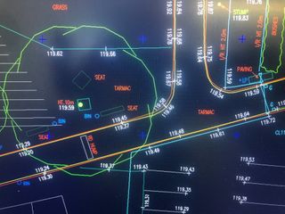
Drawings issued using an AutoCAD file or a PDF file
State-of-the-art surveying equipment achieving fast results
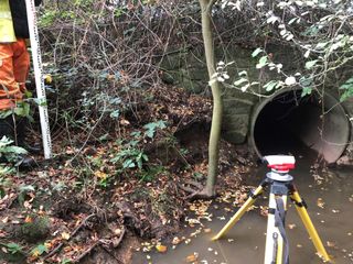
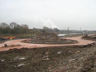
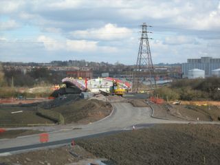
Accurate Topographic Surveys
Whether you are a Developer, Self-Builder or Homeowner just looking to add an extension, Rugby Site Services Ltd can provide you with a Topographical Survey tailored to suit your individual needs.
A Topographical Survey is a fully scaled representation of your site. It will identify boundaries, existing buildings including neighbouring properties, ground levels and ground features such as roads, slopes and watercourses. Existing drainage and Trees. The Survey can either be coordinated to the Ordnance Survey national grid or a local grid.
Commissioning a Topographic Survey at the Design and Planning stage of your project will enable your Designers to identify any site constraints, ensuring that your site is used to its full potential. Once the survey is complete a drawing is produced and issued as an electronic PDF and AutoCAD file to enable your Architect to commence work.
As-Built Survey
Whether you are a Developer, Self-Builder or Homeowner just looking to add an extension, Rugby Site Services Ltd can provide you with a Topographical Survey tailored to suit your individual needs.
A Topographical Survey is a fully scaled representation of your site. It will identify boundaries, existing buildings including neighbouring properties, ground levels and ground features such as roads, slopes and watercourses. Existing drainage and Trees. The Survey can either be coordinated to the Ordnance Survey national grid or a local grid.
Commissioning a Topographic Survey at the Design and Planning stage of your project will enable your Designers to identify any site constraints, ensuring that your site is used to its full potential. Once the survey is complete a drawing is produced and issued as an electronic PDF and AutoCAD file to enable your Architect to commence work.
Volumetric Surveys
If you are a first time Developer or Self-Builder sometimes you may not expect the added cost of transporting excess excavated material from site. You may be surprised that building on a sloping site or excavating a basement could mean lorry after lorry transporting ‘muck away’ at significant cost.
As part of a previously commissioned Topographic Survey either by Rugby Site Services or others, original ground levels are collected and can be used to create a Digital Terrain Model (DTM). DTM’s are an electronic 3d model of the terrain on your site.
A DTM can also be created of the sites proposed finished levels. The two surfaces are then compared to calculate any excess material that will be generated or alternatively any shortfall of material that may need to be imported.
Value Engineering
Value Engineering is the process of suggesting alternative methods of construction that could save the client time and money. Having carried out a site survey, volume calculations and viewed design drawings, Rugby Site Services is in a perfect position to offer ideas that ultimately save money.
Drop us an email to find out more about our services
info@rugbysiteservices.co.uk


